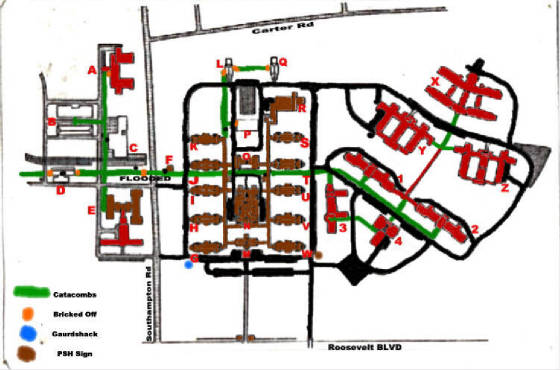
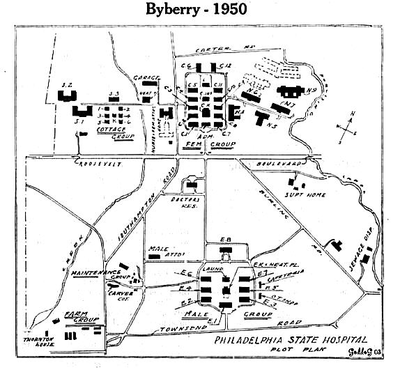
Philadelphia State Hospital

Maps

Home
The Story Part 1: 1906-1937
The Story Part 2: 1938-1959
The Story Part 3: 1960-1999
The Story Part 4: 2000-2006
Epilogue
Before and After Photos
Patient Necrology
Byberry Photo Collection (2003-2007)
Byberry Videos
Maps
The By-Line Newsletter
Documents
Official Blueprints and Floor Plans
Aerial Photos
Links
Contact

picture2.jpg
THIS MAP IS FROM THE PRECEDING BY-LINE NEWSLETTER

byberymap1.jpg
Byberry Circa 1980

byberrycampusmap2000.jpg
Map from the demolition of the South Group showing cottages as Chapels, 2000

map3.jpg

MAP LEGEND

  • A-  Laundry (S-8)
  • B-  Garages
  • C-  Warehouse
  • D-  Power Plant
  • E-  Nurses' Quarters (S-10, now Self Help)
  • F-  Electrical Substation
  • G-  C-1
  • H-  C-2
  • I-   C-3
  • J-   C-4
  • K-  C-5
  • L-  C-6
  • M-  Old Administration
  • N-  Old Cafeteria/Maintenence
  • O-  C-14 Infirmary
  • P-   Remains of old Laundry (C-13)
  • Q-  C-12
  • R-  Furey Ellis Hall
  • S-  C-11
  • T-  C-10
  • U-  C-9
  • V-  C-8
  • W- C-7
  • X-  N-10 (TB Hospital)
  • Y-  N-8 (Max Security Female)
  • Z-  N-9 (Max Security Male)
  • 1-  W-6
  • 2-  W-7
  • 3-  W-3 (Active Therapy Building)
  • 4-  W-5 (Cafeteria/Dietary)

ariallabeled2.jpg

map1.jpg